【卫报图集】太空俯瞰地球之农业奇迹
- anders - 译言-每日精品译文推荐来源Agricultural patterns from space – in pictures | Environment | guardiancouk. NASA的卫星图片揭示了从太空中所见的农田图案,其色彩的缤纷程度令人惊叹,仿佛是人力和自然力在大地上共同绘制的现代抽象艺术画. 图片来源:国际空间站/NASA.
原作者:
来源Agricultural patterns from space – in pictures | Environment | guardiancouk
译者Lineker
Nasa satellite images reveal the diversity of agricultural patterns as seen from space
NASA的卫星图片揭示了从太空中所见的农田图案,其色彩的缤纷程度令人惊叹,仿佛是人力和自然力在大地上共同绘制的现代抽象艺术画
Photograph: ISS/Nasa
图片来源:国际空间站/NASA
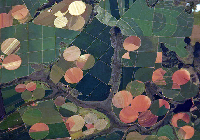
Agricultural fields south-west of Perdizes, Brazil, photographed from the international space station. A mix of regularly gridded polygonal fields and circular centre-pivot fields mark the human land use of the region. Small tributary streams (and their adjacent floodplains) of the Araguari river extend throughout the agricultural landscape. The visual diversity of field forms is matched by the variety of crops produced here: sunflowers, wheat, potatoes, coffee, rice, soybeans and corn
国际空间站所拍摄的巴西佩尔蒂泽斯(Perdizes)西南部的农田。整齐的网格状多边形地块和圆形中枢轴地块标示出了这一地区的土地利用情况。阿拉圭里河(Araguari river)的小支流(以及毗邻的冲击平原)在农田中间延伸。农田样式的视觉多样性在于其中种植的作物也不尽相同,有向日葵、小麦、马铃薯、水稻、大豆和玉米。
Photograph: ASTER/Terra/Nasa
图片来源:ASTER/Terra卫星/NASA
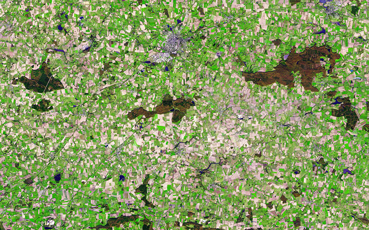
Vestiges of Medieval Brittany among signs of modern civilisation in this simulated natural colour satellite image of Chateaubriant, France. The small city is silver, coloured by light bouncing off the reflective surfaces. The surrounding country is an irregular patchwork of small fields, reflecting land use in the Middle Ages. Plant-covered land is still green and water is dark blue. By late November, crops had been harvested and many of the fields were bare. The exposed soil ranges from pale tan to brown in the image. Other fields (possibly pastures) remained green, even late in the year. Patches of forest on the right and lower edges of the image are brown and dark green
在这张法国夏多布里昂(Chateaubriant)的模拟自然彩色卫星照片上,现代文明标志中的中世纪布列塔尼(Brittany)遗迹依然清晰可见。因为光线被地表反射的缘故,照片上的小城呈现出银白色。其周围的乡野由小块田地不规则拼接起来,其代表了中世纪的土地利用情形。植被覆盖的土地依然绿意盎然,暗蓝色的点状分布为水源。时值十一月底,庄稼收割完毕,很多田地变得光秃秃的,暴露出来的土壤颜色从灰白色到褐色不等。其他地块(可能是牧场)在时近隆冬依然保持着绿色。右边和下方的小块森林呈现褐色和暗绿色。
Photograph: Nasa
图片来源:NASA
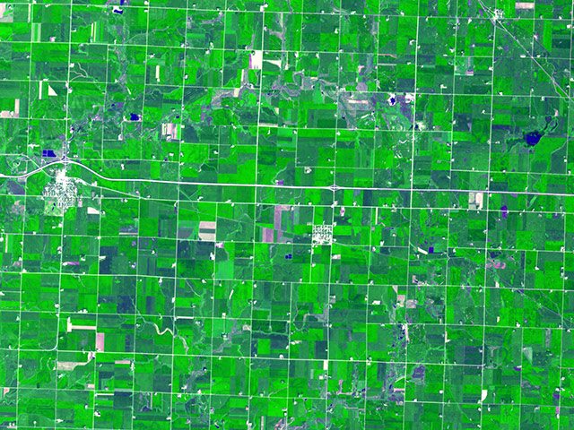
In Minnesota the very regular grid pattern reflects early 19th-century surveying; the size of the fields was determined by the need to have a big enough area to make the use of machinery efficient
这片位于明尼苏达州的网格状农田排布非常整齐,它反映了十九世纪早期的土地测量技术;机械工具的使用需要有足够大的区域,因此这些田地的面积相当巨大。
Photograph: Nasa
图片来源:NASA
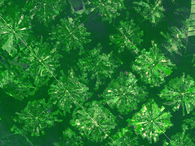
Near Santa Cruz, Bolivia, the radial-pattern fields are part of a planned settlement scheme in a rainforest area. At the centre of each unit is a small community, which is surrounded by fields. A small buffer of forest separates the settlements from one another
玻利维亚的圣克鲁斯(Santa Cruz)附近,呈现辐射图案的农田是雨林地区农业生产的解决方案之一。每个土地单元的中心都是一处小村落,它被周围的田地所包围。而小片的森林缓冲区则将这些定居点彼此分隔开来。
Photograph: Nasa
图片来源:NASA
Outside Bangkok, Thailand, rice fields fed by an extensive network of canals that is hundreds of years old appear as skinny rectangular fields. Some fields seem to be flooded (deep purple), which is part of the growing cycle of rice plants
在泰国曼谷的周边地区,河流形成的密集网络为稻田提供灌溉,这些灌溉渠道已有上百年历史,它们将田地分割成小块的矩形区域。一些稻田似乎正被浸没在水中(深紫色区域),这是水稻植物在其生长周期中必须经历的阶段。
Photograph: Landsat 5/Nasa
图片来源:地球资源5号卫星/NASA
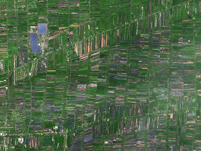
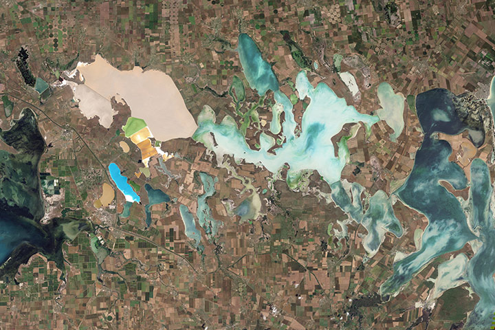
From mainland Ukraine, the Crimean peninsula extends southward, bordered on the west by the Black Sea and on the east by the Sea of Azov. Stretching across the peninsula is a network of shallow, marshy inlets sprawling over roughly 1,000 square miles (2,600 square kilometres). This network of lagoons is known as Sivash (also Syvash or Sivasÿ). Surrounding the marshy areas are agricultural fields, most of them rectangular, but some are shaped by centre-pivot irrigation systems. Urbanised areas appear along the shores of the Black Sea, and highways curve and zigzag across the peninsula
克里米亚半岛(Crimean peninsula)从乌克兰本土向南延伸,邻近西边的黑海和东部的亚速海(Sea of Azov)。狭长的半岛形成了一个散布于2600平方公里土地上的沼泽浅水湾网络,这个泻湖网络被称之为锡瓦什海(Sivash),其周围是农田,大部分为矩形,也有一些田地被中枢灌溉系统塑造成其他样式。城市化区域分布于黑海沿岸,高速公路系统在整个半岛地区纵横交错。
Photograph: ASTER/Terra/Nasa
图片来源:ASTER/Terra卫星/NASA
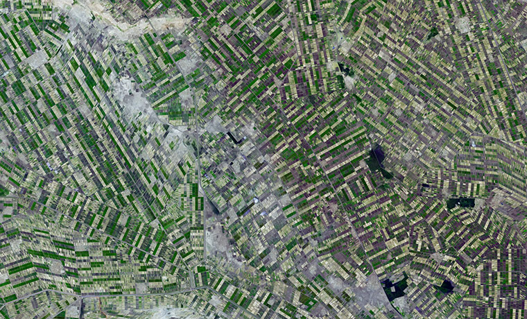
South of Khartoum, Sudan, where the White and Blue Nile rivers join, a dizzying arrangement of irrigated fields stretches out across the state of El Gezira. Given the semi-arid climate of the surrounding area, this geometrical spectacle of fertile green fields depends on thousands of miles of canals and ditches that connect the region to the Blue Nile in the west. The man-made rivers and streams are part of an irrigation project called the Gezira scheme, which the British started in the colonial era to grow cotton for export back to Europe
白尼罗河与蓝尼罗河在苏丹的喀土穆以南地区相汇合,图中令人目眩的灌溉地即位于这一地区的杰济拉(El Gezira)州。虽然周边区域属于半干旱气候,但这片肥沃绿地依赖与西边蓝尼罗河相连的数千公里运河和水道却一直保持着欣欣向荣的态势。人造河流是杰济拉灌溉工程的一部分,为了在这里种植棉花出口到欧洲,殖民地时期的英国人首先发起了这项工程。
Photograph: ASTER/Nasa
图片来源:ASTER/NASA
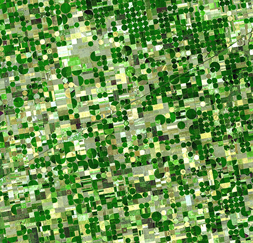
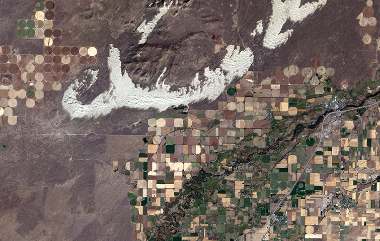
Resembling a work of modern art, variegated green crop circles cover what was once shortgrass prairie in south-western Kansas. The most common crops in this region are corn, wheat, and sorghum. Each of these crops is at a different point of development, accounting for the varying shades of green and yellow
在堪萨斯州的西南部,曾经的短草牧场因为被圆形的饲料作物田地点缀而变得斑驳起来,整张图片宛如一幅美妙的现代艺术作品。这片区域中最普遍的作物为玉米、小麦和高粱,由于成熟进度的不一致,导致图片呈现绿色和黄色的阴影变化。
Photograph: ASTER/Terra/Nasa
图片来源:ASTER/Terra卫星/NASA
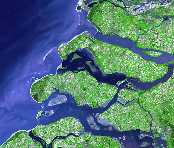
The south-western coastline of the Netherlands is a series of islands crisscrossed with river outlets and estuaries. The patchwork of green, cream, and lavender colours on the islands shows the prevalence of agriculture in the province and fields in various stages of growth or harvest
荷兰西南海岸遍布着岛屿群,河口和水湾交织其中。岛屿上的绿色、白色和淡紫色区域为处于不同收获期的农田。
Photograph: ALI/EO-1/NASA
图片来源:ALI/地球观测-1号卫星/NASA
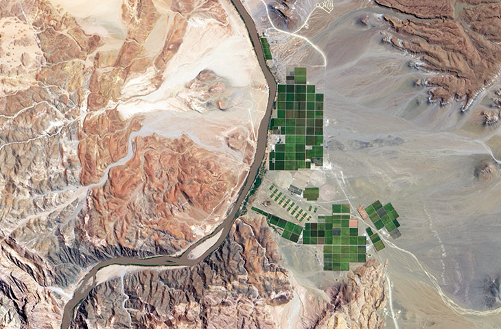
The Orange River serves as part of the border between Namibia and South Africa. Along the banks of this river, roughly 100km (60 miles) inland from where the river empties into the Atlantic Ocean, irrigation projects take advantage of water from the river and soils from the floodplains to grow produce, turning parts of a normally earth-toned landscape emerald green
奥伦治河(Orange River)充当了纳米比亚和南非之间的部分国界线。这条河流最终流入大西洋,从入海口向内陆纵深100公里的河流沿岸区域,灌溉系统利用河水维系了泛滥平原上的农业生产,使土黄色的大地上冒出了一片鲜绿色。
Photograph: ISS/NASA
图片来源:国际空间站/NASA
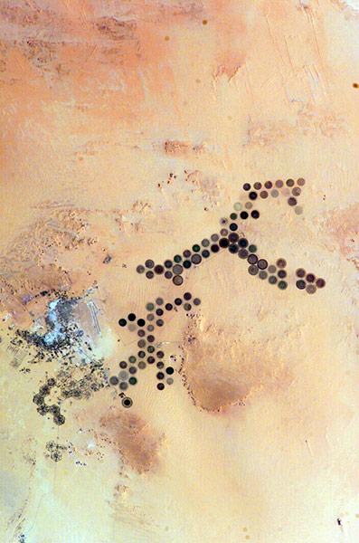
Green circles in the desert frequently indicate tracts of agriculture supported by centre-pivot irrigation. The Al Khufrah oasis in south-eastern Libya is one of Libya's largest agricultural projects. Because only about 2% of Libya's land receives enough rainfall to be cultivated, this project uses fossil water from a large underground aquifer. Darker colours indicate fields where such crops as wheat and alfalfa are grown. Lighter colours can indicate a variety of agricultural processes: fields that have been harvested recently; fields that are lying fallow; fields that have just been planted; or fields that have been taken out of production
这片位于沙漠里的密集绿圈代表由中枢灌溉系统支持的农业生产。位于利比亚东南部的阿尔库夫拉赫绿洲(Al Khufrah oasis)是利比亚最大型的农业生产项目之一。由于降水稀少,导致利比亚只有2%的国土适宜作物种植。图中的这片区域依靠大型地下蓄水层中的矿物水进行灌溉,黑色表示种植的是小麦和苜蓿,浅色则表明田地的农耕进程不一致:最近刚收获完毕、处于待垦状态、刚被种上庄稼或正在收获。
Photograph: ALI/EO-1/NASA
图片来源:ALI/地球观测-1号卫星/NASA
Sand dunes spill across the Snake River plain in Idaho. Freshly harvested fields line the southern boundary of the dunes, and to the north is a darker brush-covered lava plain
沙丘散落于爱达荷州的斯内克河(Snake River)平原上。刚收获完毕的田地位于沙丘的南部边界,北边则是灌木覆盖的暗色熔岩平原。
相关文章:

